The Kettle Valley Railway is a must for the serious hiker as you walk across railway trestles for a view of the Okanagan's beauty.
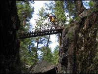
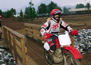
Hard core mountain bikers may scoff at the Kettle Valley Railway (KVR), an abandoned railway bed that winds through south central British Columbia between Midway and Hope. It is after all a typical railway bed with grades that never exceed 2.2 %. But even the most radical mountain biker will grip the handle bars a little tighter crossing trestles hanging precariously on the sides of Myra Canyon. With countless trestles and tunnels, and environs ranging from cool mountain forests to Canada's only pocket desert the 600 km route offers an endless diversity of experiences.
Abandoned railway corridors hold unparalleled opportunities as recreational trails, and the Kettle Valley Railway is no exception. This corridor is one of the most dynamic routes in Canada, with some truly impressive scenery and spectacular views. The easy grade in most sections makes it suitable for either casual family cycling or easy day riding. The 600 kilometres of travel routes make it challenging for the more adventuresome. Utilizing the numerous unique accommodations and camping facilities along this route allows for weekend or extended trips. Cycling this trail is truly a dynamic and challenging venture that unfolds over the expanse of place and time.
The British Columbia government in it's purchase of the Kettle Valley Railway corridor, voiced a strong commitment to preserve the railbed so that is can play a part in the future of British Columbia just as it did in it's past. Over many years, and with the coordinated efforts of numerous groups and individuals, the conversion of the abandoned Kettle Valley Railway to a multi-use corridor and inclusion in the Trans Canada Trail system is being realized.
http://www.planet.eon.net/~dan/kvr.html
Wild Horse Canyon
Take Lakeshore Road to its end, about 16 km south and west of Kelowna. Park on the right. The trail goes off on the left. Walk about 3 km and cross a creek, then continue on an uphill road another 5 km to the canyon. You can walk through the canyon to Okanagan Lake and back (total about 22 km) or climb the gully (this is the west wall) in the main canyon and return via ridges and the rim north of the canyon. The trail gradually descends and heads back to the trail by the creek. An alternative is to leave the canyon in the middle and angle uphill southeast to the two little lakes! When you get there, drop down past the lakes to Good Creek Canyon and follow the creek for about 3 km. Head north through the old Kettle Valley Railway station and head downhill on the slopes facing the lake. You'll regain the trail at the bottom.
Mission Area includes Myra Canyon and June Springs and Rose Valley Reservoir" Drive Lakeshore Road south, past the end of the pavement. Look for dirt roads going off to the left.
Myra Canyon
Follow K.L.O. Road to McCulloch Road, which you follow past the pavement. About 2 km after the pavement ends, you'll come to a clearing where power lines cross above the road and on the right is the Myra Forest Service Road. Follow this road for 8 km and look for the parking area. The trestles are about a 15 minute walk.
June Springs
Follow K.L.O. Road to McCulloch Road and go right onto June Springs. This road is windy and takes some unpredictable turns. Be alert! June Springs Road turns into Little White Forest Service Road. The KVR cuts across this road and looks like another dirt road at this point. There is a small parking area on the left and that is the direction to Myra Canyon and the trestles. The first trestle is about 2 km from this point. For Chute Lake: Follow Lakeshore Road south from Kelowna and go straight onto Chute Lake Road. Turn left onto Hedeman Road and right onto Gilliard Forest Service Road. The KVR crosses but looks like another dirt road. Park in this area and walk about 5 km to your left to reach the first trestle.
Rose Valley Reservoir
Follow Hwy. 97S west from Kelowna and turn right onto Bartley Road, just past Byland's Nursery. Stay on Bartley until you cross a cattle guard and then park. Start walking on the main trail and stay on it until you reach a sign that shows the route to Rose Valley Reservoir. About 2 km along this road you will reach the southern end of the reservoir. Walk on your left (west) side of the reservoir to the north end (about 3 km). You can cross the creek at that end and hike back to your car. Be aware that the last bit is a steep downhill section.
.
KVR - Naramata
The Kettle Valley Railway right-of-way has become a favourite travel route because of its easy grades and spectacular scenery. the length of this portion of the trail is about 60 km. The Rock Ovens, two tunnels and the cool oasis of Chute Lake Resort are highlights of this trail loop which takes about 4 hours to bike. Rock Oven Park contains several interesting features of historical significance. The rock ovens were constructed along the Kettle Valley right-of-way above Naramata, built between 1911 and 1915. To locate them, watch for a wide spot in the grade just before it enters a rock cut. You can follow a fairly well-used trail up the hillside to a fine specimen of the rock ovens that once served the railway construction crews.
One of the most spectacular viewpoints is at the mouth of Little Tunnel. Below to the south, the scattered ponderosa pine and bunchgrass gives way to the neatly manicured orchards of Naramata and then the beaches and cityscape of Penticton. Skaha Lake disappears around the bend on the horizon.
The 489 metre long Adra Tunnel carves a curve within the mountain and a weak spot in the roof near the mid-point is slowly caving in. The tunnel is barricaded and a hiking/biking trail bypasses it.
Excerpts quoted from Okanagan Trips & Trails, A Guide to Backroads and Hiking Trails in BC?s Okanagan-Similkameen Region. See this site for details.
Directions:
Travel to Penticton via Highway 97, turn east onto Westminster Avenue and follow this road through to Naramata. There are many access points for this section of the trail. The best place to connect with the Kettle Valley Rail in this area is at Smethurst Road located east off Naramata Road, just past the main turnoff down to Naramata. A second access point is at Arawana Road also located east of Naramata Road. An access point further down the line is located where the KVR transects Chute Lake Road at the three km mark.
KVR- Penticton
The section of track from the Summerland south to Trout Creek has been recreated and has a replica KVR passenger train that runs in the summer months. Past Trout Creek the KVR trail runs on top of clay cliffs overlooking Okanagan Lake, before dipping down into the City of Penticton.
Leaving Vancouver Place (at the northeast edge of Penticton) toward Naramata expect to pass over Andrew McCulloch trestle with some beautiful views of the Okanagan Valley. Between these two communities there are nine little wineries and vineyards to take in along the way. This section of the KVR is about 40 km and takes about 5 hours to bike.
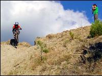
Nkwala Mtn / Jerry Mtn
Located in the Penticton area this is about a 40 minute bike climb to the Nkwala Saddle overlooking trout creek and Penticton. From there you can either keep climbing to the tower or enjoy the nice bomb down to the west bench. this is considered a singletrack downhill. Lots of fun turns and a couple jumps.
Directions:
Start at the Summerland KVR Trestle just past summerland sweets. Go over the trestle and after about 2km there is a trail exiting to the right.
When you reach the saddle you can either continue up the road to the Radio Tower or cut off the trail to the left. The trail to the left is the start of a really fun downhill bomb that ends up in the west bench near the sage mesa golf course. You can then ride back to Summerland or you can begin and end your loop in Penticton.
COMMENT ON OUR TRAIL NETWORK
Please enter your comments in the Guestbook below.
Feel free to update our readers on your experiences.
Please correct our information or add further information about the trails and water routes on this page, or just say hello!