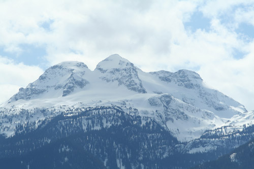
The Columbia Mountains are steep and the valleys narrow. the region includes the communities of Revelstoke, Golden abd Three Valley Gap all accessed by the Trans-Canada Highway.
The Columbia Mountain Range in its entirety represents a group of mountain ranges located in British Columbia, and partially in Montana, Idaho, Washington. The mountain range covers 135,952 km² (52,491 sq mi). The range is bounded by the Rocky Mountain Trench on the east, and the Kootenai River on the south; their western boundary is the edge of the Interior Plateau. Seventy-five percent of the range is located in Canada and the remaining twenty-five percent in the United States; American geographic classifications place the Columbia Mountains as part of the Rocky Mountains complex but this designation does not apply in Canada (despite a British Columbia government tourism campaign to rebrand their southern portion as the "Kootenay Rockies"). Mount Sir Sandford is the tallest mountain in the range reaching 3,519 metres (11,545 ft).
Hikers will often be sharply reminded that many of the trails here were originally built as access to mountain climbs and glaciers! Most of the Illecillewaet-area day hikes involve an elevation gain of about 1,000 meters between the start of the trail and the "End of Trail" sign. However, the trails are well constructed and well-marked; and they will take you to stunning ridges and viewpoints that will make you forget your uphill toil. Adjust your pace and your mindset and you will be greatly rewarded!