Coquihalla Canyon Provincial Park
http://www.env.gov.bc.ca/bcparks/explore/parkpgs/coquihalla_cyn/
Located off Highway # 5, just north of Hope, the Coquihalla Canyon Provincial Park is home to the famous Othello Tunnels which is an easy walk and a 3.5 km round trip. This Trail is part of the Trans Canada Trail and features a flat gravel surface.
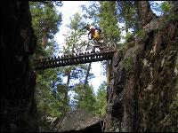
In the early 1900s, the Canadian Pacific Railway decided a route was necessary to link the Kootenay Region with the BC coast by rail. The railway was built over three mountain ranges. In the Coquihalla Gorge - the river cut a 300 foot deep channel of solid granite. A straight line of tunnels were built through it which are known now as the Othello Tunnels. There are spectacular viewing opportunities available on the trail, through the tunnels and on the bridges. This park highlights the Kettle Valley Railway grade that passes through the canyon and five tunnels which were built in 1914. It contains a 135-hectare land base. It is a popular tourist attraction for the town of Hope and provides viewing, walking, fishing and picnicking opportunities. The hiking trail links to the historic Hope-Nicola Cattle Trail. The engineer Andrew McCullough was an avid reader of Shakespearean literature, and used characters such as Lear, Jessica, Portia, Iago, Romeo & Juliet to name stations of the Coquihalla subdivision.
Today, only the faint sound of train whistles from the past can be heard along the trail as the route has become home to only bicycle and foot traffic. Bicycles must keep to roadways. Bicycle helmets are mandatory in British Columbia. Cyclists please dismount and walk through tunnels.
A flashlight is recommended, as lighting is dim while walking through the tunnels. In recent years, the tunnels have become a favorite location for movie producers. Cyclists must dismount from bicycles while passing through the tunnels.
Pets are allowed on the hiking trail only and must kept on a leash at all times. You are responsible for their behaviour and must dispose of their excrement. Backcountry areas are not suitable for dogs or other pets due to wildlife issues and the potential for problems with bears.
The following represents a few links to map downloads. Any maps listed are for information only - they may not represent legal boundaries and should not be used for navigation.
· Park Map (75 kb pdf)
·Park Brochure (63 kb pdf)
Manning Park
http://www.env.gov.bc.ca/bcparks/explore/parkpgs/ecmanning/
E.C. Manning Park (hereinafter called Manning Park) is a focus of outdoor recreation that is unique in British Columbia. This Provincial Park is located in the heart of the Cascade Mountains it is within a three-hour drive from either Vancouver or the Okanagan. The climate and geography have combined to make this park an all season recreation area. Bisected by Hwy. 3, Manning Park is one of the most popular destination areas in the province. The landscape diversity of this park combined with four seasons’ development and easy access are the prime factors, which stimulate visitor interest. The park contains a large number of scenic, historic, floral and fauna attractions and provides a wide range of both summer and winter recreational opportunities.
For your convenience, during the summer season this park has a concession managed by the Park Facility Operator. To simplify finding information, E.C. Manning Provincial Park is divided into two areas:
Frontcountry opportunities along the Highway 3 Corridor-vehicle accessible camping, day-use, easy interpretive trails
Backcountry/wilderness opportunities-longer hiking trails, horse use and wilderness camping
The park has a large variety of walking/hiking trails which range anywhere from a 15-minute walk to a 5 or 6 day hike. For your own safety and the preservation of the park, obey posted signs and keep to designated trails. Shortcutting trails destroys plant life and soil structure. During the winter season, all trails are closed for hiking due to snow.
The plants in this park are susceptible to winds, rain, extended periods of dry weather, heavy snow fall and a very short growing season. For this reason we ask that you and your pets stay on the trails, don't trample or pick the flora.
Manning Park Hiking Trails
Below is a list of trails in the park as supplied by BC Parks. Please note that trail conditions can change quickly due to weather conditions. More detailed trail descriptions are available by clicking on the individual links below:
EASY
Lightning Lake Loop- 9km return/ 2.5 hours. Trail begins at Lightning Lake Day Use area or at the Spruce Bay parking lot.
Lightning Lake Chain- 12 km one way from Day Use area/ 3.5-4.5 hours; or 10 km, one way from Spruce Bay/ 3-3.5 hours.
Rhododendron Flats- this 20 minute walk, located 32 km west of the Manning Park Resort travels through an impressive stand of red rhododendrons; peak bloom usually June 1-15.
MODERATE
Castle Creek/Monument 78: 12km one way / 3.5hours / elevation change: 200m. Trail starts at Monument 78/83 parking lot.
Dewdney Trail: 36km one way / 14-16 hours / elevation change 1131m. Trail begins at the Cascade Recreation Area parking lot and ends at Dick's Cabin in the Cascade Recreation Area.
Heather: 21km one way to Nicomen Ridge / 8-10 hours / elevation change 292m. Stat at Blackwall parking lot.
Hope Pass Trail: easy-moderate 23.5km one way / 10 hours / elevation change 1000m; begins at Cayuse Flats.
DIFFICULT
Bonnevier: 25km one way / 8-10 hours / elevation change: 950m. Begin at Blackwall Peak parking lot.
Frosty Mountain Loop: 29.3km or 27.7km depending on route / 9-11 hours / elevation change: 1150m. Begin just past dam on eastern end of Lightning Lake.
Grainger Creek: 17.5km one way (includes 6km along Hope Pass Trail)/ 5-7 hours / elevation change: 952m. Begin 25km west of the Visitor Centre at Cayuse Flats.
Monument 83: 16km one way/5 hours/elevation change: 850m. Begin at Monument 78/83 parking lot.
Pacific Crest Trail: 13km one way/4 hours/elevation change: 450m. Begin at Windy Joe/Pacific Crest parking lot on the Gibson Pass Road.
Poland Lake: 8km one way/2.5-3 hours/elevation change: 435m. Begin at Strawberry Flats parking lot.
Skyline I: 20.4km loop / 7-9 hours / elevation change: 775m. Begin at Spruce Bay parking lot or Strawberry Flats.
Skyline II: 12.5km to Mowich Camp / 5 hours / elevation change: 469m. Begin at Strawberry Flats.
Whatcom: 13km one way / 6-7 hours / elevation change: 1082m. Begin at the Cascade Recreation Area parking lot.
Windy Joe Mountain: 16km return / 4.5-5.5 hours / elevation change: 525m. Begin at Windy Joe / Pacific Crest parking lot on the Gibson Pass Road.