Knox Mountain - Easy/Moderate
This park is located in the downtown area. Take Ellis Street North all the way to the end to reach the park entrance. Parking is at the bottom of the mountain, at mid point, and at the top. Paul's Tomb is accessible from Poplar Point Drive. However most trails are accessible from the entrance on Ellis Street. These trails are not for the faint at heart since most are very steep.
Mission Creek Regional Park - Easy/Difficult
This park is located on Springfield Road east of Orchard Park Mall. Cycling Trails run along Mission Creek. Some of the trails are not accessible for bikes so it's important to check the map at the park entrance. These trails are great for beginners and families.
McDougall Rim - Moderate/Difficult
The trailhead for McDougall Rim is located 3kms north of the Hwy 97 on Bartley Road. The last 1.5kms of road is unpaved (please be sure to obey property owner's signs and drive slowly). The trail follows ridgeline above Rose Valley Lake and Lambly and Douglas Creeks. Marshy areas, rock outcroppings,
Angel Springs - Moderate 4 kms (one way)
The trail to Angel Springs is 4 kms one way. Though the springs aren't for bathing, the geological formations and mineral deposits are an interesting sight. The trailhead is located on the east side of Little White Forest Service Road at kilometer four. To reach the trailhead from Kelowna take K.L.O. Road to McCulloch Road then to June Springs Road Follow June Springs to Little White Forest Service Road.
Knox Mountain to Paul's Tomb - Easy/Difficult
This park is located in the downtown area. To access the trail to Paul's Tomb take Ellis Street north, turn left onto Poplar Point Drive, follow Poplar Point Drive until you see the park entrance. Parking is limited. To hike other areas of Knox Mountain, take Ellis street north to the top of the mountain. Maps of the trails are available from the City of Kelowna or from Kelowna Tourism.
Glen Canyon Regional Park - Moderate
Glen Canyon is located on the Westside in Glenrosa. To access the park from Downtown Kelowna take Hwy 97 south to Westbank, drive through downtown Westbank, turn right on Lower Glenrosa Road, left on Glenway, and right again on Glengarry. Follow Glengarry to the park entrance. Please, no dogs.
Rose Valley Reservoir - Moderate
To hike the Rose Valley Reservoir, take Hwy 97 across the bridge toward Westbank, turn right on Bartley Road. Take Bartley Road until you cross a cattle guard; find a place to park. Start walking on the main trail until you see the sign indicating the route to Rose Valley Reservoir.
Bear Creek Provincial Park - Moderate/Dogs Allowed
The hike at Bear Creek has a lot of stairs, but the view is well worth it. To reach the park from downtown Kelowna, take Hwy 97 south across the bridge; turn right on Westside Road and follow the signs to the Provincial Park.
Hardy Falls - Easy
The hike to Hardy Falls is located adjacent to Antlers Regional Park in Peachland. The hike is 4 km south of Peachland on Hwy 97.
Brant's Creek to Glenmore Valley Linear Park - Easy 1 km/No Dogs
This trail is approximately 1 km one way. The park can be entered on Valley Road on the east side of Glenmore Drive, or on the west side of Glenmore Drive on Biggar Road. To enter the park on Valley Road from downtown Kelowna, take Glenmore Drive to Yates; turn right on Yates. There is no parking on Valley Road so you should park on Yates and walk around the corner to the bird sanctuary on Valley Road where the park entrance is located. To enter the park on the other end, take Glenmore to Biggar; turn left on Biggar; drive to the end of the road and park.
Downtown City Park to Water Front Park - Easy 2 kms/No Dogs
The walkway along the lake through City Park and Waterfront Park is accessible from Water Street or Abbott Street in Downtown Kelowna. Just find a place to park downtown and head toward the waterfront. Parking is available in City Park, at the Grand Okanagan Hotel, at the Chapman Parkade off Lawrence, and the Library Parkade off Ellis.
Mission Creek Regional Park - Moderate 12 kms of trail/Dogs allowed
Mission Creek Regional Park includes a linear walking, cycling, and jogging area that follows Mission Creek from the entrance at Springfield Road to Lakeshore Road. There are also some easy hiking trails throughout the park. To access the park from downtown Kelowna; take Hwy 97 to Dilworth Drive; turn right on Dilworth and follow Dilworth to Springfield Road. The park is located at the end of Dilworth where Dilworth bisects Springfield.
Kalamoir Park - Moderate/Dogs allowed but not on the beach.
To access Kalamoir park from downtown Kelowna take Hwy 97 across the bridge; turn left on Boucherie Road, then right on Ogden; left on Thacker; right on Collins Hill Road. Follow Collins Hill road into the park.
Gellatly Heritage Park & Nut Farm - Easy/No Dogs
The Gellatly Nut Farm is located on the Westside of Okanagan Lake on Gellatly Road. To access the park from downtown Kelowna, take Hwy 97 across the bridge, turn left on Boucherie Road, follow Boucherie road along the lake until it turns into Gellatly Road. The portion of Gellatly Road just before the park is unpaved.
Trepanier Creek Linear Park - Moderate 9 kms/Dogs allowed
Trepanier Creek linear park is located on the Westside in Peachland. The park can be accessed from Beach Avenue, just after the boat launch.
Kelowna Crags
Head south from downtown on Lakeshore Road and stay straight at the fork on to Chute Lake Road. Once on the gravel road, go about 7 km and watch for an old dirt road on the right. Take this road to an old sawmill site and park. About 1/2 km after you cross the creek past the old cabin, cliffs will come into view on your left. You can hike down to the bottom of the cliffs (about 300 feet high). The trail leads up to the cliff top at the north end. Depending on where you left your car, it's about a 6.5 km walk. The view from the cliff top is beautiful at about 2,500 feet.
Wild Horse Canyon
Take Lakeshore Road to its end, about 16 km south and west of Kelowna. Park on the right. The trail goes off on the left. Walk about 3 km and cross a creek, then continue on an uphill road another 5 km to the canyon. You can walk through the canyon to Okanagan Lake and back (total about 22 km) or climb the gully (this is the west wall) in the main canyon and return via ridges and the rim north of the canyon. The trail gradually descends and heads back to the trail by the creek. An alternative is to leave the canyon in the middle and angle uphill southeast to the two little lakes! When you get there, drop down past the lakes to Good Creek Canyon and follow the creek for about 3 km. Head north through the old Kettle Valley Railway station and head downhill on the slopes facing the lake. You'll regain the trail at the bottom.
Gallagher's Canyon
Follow McCulloch Road East from Kelowna and turn left on Field Road just past Gallagher's Canyon Golf Course. It's about 1 km to the parking lot. You can walk any distance from 3 to 15 km. Okanagan Mountain - Take Lakeshore Road south from Kelowna past where the pavement ends and park in the lot on the right. Look for a chained gate on the left and take that road to the summit. The view is excellent and the elevation is 5,158 feet.
Mission Area
Drive Lakeshore Road south, past the end of the pavement. Look for dirt roads going off to the left. These are all suitable for walking. Vegetation is thick near Lakeshore Road but thins out after several hundred feet of elevation. This is an excellent area for almost unlimited off-trail hiking. To get back, simply head downhill to Lakeshore Road, but be aware of private property.
Black Knight Mountain
Follow Highway 97 north through Kelowna and turn right at Hwy. 33. About 8 km east of Rutland, turn left on Pyman Road and keep to the right. You can either drive or walk the road (about 6.5 km) to the Forest Lookout Tower at the top (elevation 4,205 feet). You'll get an excellent view of Kelowna and the surrounding area from the top of this mountain.
Big White Mountain
Take Hwy. 33 out of Kelowna to the Big White turnoff. Drive to the parking lot at Big White Ski Resort and park there. You can walk up the Alpine area of the mountain but be sure to keep the lift towers in view both coming and going. The best time of the year for this hike is August to see the Alpine flowers. The maximum elevation is 7,600 feet.
Rose Valley Reservoir
Follow Hwy. 97S west from Kelowna and turn right onto Bartley Road, just past Byland's Nursery. Stay on Bartley until you cross a cattle guard and then park. Start walking on the main trail and stay on it until you reach a sign that shows the route to Rose Valley Reservoir. About 2 km along this road you will reach the southern end of the reservoir. Walk on your left (west) side of the reservoir to the north end (about 3 km). You can cross the creek at that end and hike back to your car. Be aware that the last bit is a steep downhill section.
Blue Grouse Mountain
Take Hwy. 97 south of Kelowna and the first right after the bridge onto Westside Road to the junction with Bear Creek Main by Trader's Cove. Turn left on Bear Creek Main and follow it for about 3 km. Look for a sign that says "Grouse Mountain No. 1" on the right. Park near the sign and hike 6.5 km to the top. The elevation is 4,194 feet and the view is excellent.
Mt. Drought
Follow Hwy. 97 south from Kelowna and turn right on to an old road about 1.5 km past Gorman's sawmill. Walk up the road to a power line clearance and turn left. Head south for about 1 km on the clearance and watch for a hill on the right. Hike up the hill, down the other side and up the next ridge. The maximum elevation is 2,800 feet and the view is good.
Boucherie Mountain
From Kelowna go south on Hwy. 97 and turn left on Daimler Road. Go right onto East Boundary Road and park. Trails leave from the road.
Hayman Lake
Head south from Kelowna on Hwy. 97 and turn right onto Bartley Road. Follow Bartley Road and watch for an old road going off to the right about 6.5 km. Hike to the top of the ridge due east. The east view is excellent and the maximum elevation is 2,800 feet.
Bear Creek Road
Turn right off Hwy. 97 south to Westside Road and turn left onto Bear Creek Road (NOT Bear Creek Main) and continue well past the end of the pavement. After the road turns west into the valley proper of Bear Creek, watch for a cattle guard. Park here and hike up the steep hill to the left. There is no trail. An alternative is to drive further down the road, about 3 km past a steep gorge area and look for an old logging road going off to the left. Park your car and hike the road to its end. Climb to the top of the hill, which will take you to the top of the plateau, north of Hayman Lake. The maximum elevation is 4,000 feet. This trail is recommended for experienced hikers.
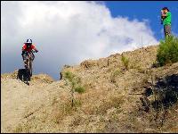
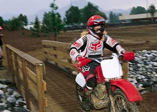
SingleTrack
Bear Creek
Trails - Awesome is the only way to describe this area. I talked to a guy who has ridden there for 7 years and is still finding new trails.
Fun Factor - Again every level can ride here. Windy single track, great hill climbs and then head for a dip in the lake so you can refresh and do it all over again.
Go across the floating bridge, go right at the first light after the bridge, follow Westside Road for either 8 or 12 km. then turn left, drive up the logging road and you will see the new motocross track and the log sorting yard on your left. Keep going until the first open gravel pit on your right. Turn up the hill to the right. This is the "lower pits", you can camp here but need to bring water and there is no washroom. People also show up here for late night parties so if you are camping I suggest choosing a camp site further up the road at the "upper pits" staging area. There are washrooms here and the riding is in every direction from here.
Vapor Trail
Lots of drops ranging from 3 to 8 feet. Three manmade launches and many natural launches. Fast flowing single track from top to bottom. Each drop and launch has a by pass for the faint of heart.
rawford Estates Past Lost Lake Rd. Pass the bog by heading up Heetseeker by pass. At the bottom of Seeker turn right. Look for a white pole and a orange ribbon on your left. If you come to the bog turn back ,you have gone to far. Trail length is 2.8k
.
The Central Okanagan
Naturalists Club (CONC) based in
Kelowna, British Columbia, Canada, is a group dedicated to the conservation and stewardship of nature in the Central Okanagan Valley.
It has active groups interested in birding, botany, conservation, education, hiking in the summer (easy, moderate, and more challenging), skiing (cross-country and downhill) in the winter.
CONC holds monthly meetings with informative and interesting speakers. Many members participate on local, regional, and provincial bodies whose interests reflect ours.
CONC is involved with the Christmas Bird Count and with the Okanagan Mountain Park Birding Blitz.
Learn More...Go...
http://conc.silk.net/
Friends of the South Slope
http://www.foss-kelowna.org/
Kelowna Mountain Bike Club
http://www.okanagan.net/kmbc/
Kelowna Running Club
"The Kelowna Running Club will provide opportunities for the community to
Participate, Recreate and be Educated
in the sport of running at whatever level they choose"
http://business.silk.net/krc/
Cycling the Kettle Valley Railway
Hard core mountain bikers may scoff at the Kettle Valley Railway (KVR), an abandoned railway bed that winds through south central British Columbia between Midway and Hope. It is after all a typical railway bed with grades that never exceed 2.2 %. But even the most radical mountain biker will grip the handle bars a little tighter crossing trestles hanging precariously on the sides of Myra Canyon. With countless trestles and tunnels, and environs ranging from cool mountain forests to Canada's only pocket desert the 600 km route offers an endless diversity of experiences.
http://www.planet.eon.net/~dan/kvr.html
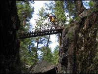
Myra Canyon Trestles
Restoration Society
In 1993, members of the community recognized that the Myra Canyon trestles and trail had become unsafe due to acts of destruction and vandalism. Ties and timbers from the trestles had been removed and had been either tossed over the edge, or pilfered. This left large gaps on the decks, making passage over the trestles quite perilous. Consequently, a small group decided to save the trestles from further destruction and the Myra Canyon Trestle Restoration Society was born. The constitution of the society reads:
(a)  To upgrade trestles in the MyraCanyon to improve safe public passage;
(b) To improve and maintain the former Kettle Valley Railway right-of-way between Little White Forest Service Road, at approximately Mile 90.5, and Myra Forest Service Road, at approximately Mile 84.5, including, but not limited to, tunnels, access, parking facilities and trailways.
From 1993 to 1995, the MyraCanyon Trestle Restoration Society, together with the generous financial support of individuals and the business community, undertook to place decks and guard rails on all 18 trestles within the MyraCanyon section of the old KettleValley Railway line.
Much of this work was destroyed by the disastrous OkanaganMountainPark fire, but the basic structure of the trail including 2 tunnels, 4 wooden trestles, and 2 large steel trestles remains intact. It is the intention of the Society, with help from the private sector and individuals, to raise funds to assist senior levels of government to rebuild all the trestles and other damaged infrastructure. For news on the progress of rebuilding the trestles
http://www.myratrestles.com/