Barnhartvale-Juniper
Trail system offers a variety of terrain. Exit off Hwy 1 East at Barnhartvale-Dallas Exit and turn right on Todd Rd. Continue up the road, turn rright on Uplands Drive, and go to the end of the street where you will find the parking area and entrance to the trails. The wide main trail goes all the way to Juniper ridge, with some ups and downs and a few narrower sections. This hike will take several hours return.
Battle Bluff
Offers a magnificent view of the Thompson River and Kamloops Lake without having to hike steep trails. Zero your odometer on the main road at the turnoff to the Kamloops Airport. Go west 5.6 km. At the junction to the farm, stay right, cross the railroad tracks and head up Criss Creek Rd. Continue on gravel road, cross Tranquille Creek. The road starts to climb out of the valley, over a cattle guard and continues upward to km 9.9 (from the airport turnoff). Go straight, onto Frederick Road, enter the Dewdrop Valley. Continue on Frederick Road for another 1.5 km, and park your vehicle well off the side of the road.
The Pinnacles (Busey Mountain)
View of Mount Peter, Mount Paul, Mount Lolo and teh South Thompson River. Travel east along Hwy 1 until the Barnhartvale/Dallas exit. Continue down Dallas Drive to Barnhartvale roas, keeping right. Follow Barnhartvale Road for approximately 8 km and turn right on Campbell Range Road. Stay to the right at the 1 km mark and continue to the Robbins Range Road. Travel 5.5 km to the beginning of the trail, where a steep dirt road veers to the left.
Embleton Mountain
Take a kilometre reading at Heffley Creek Store off the Yellowhead highway (HWY 5) north of Kamloops. Travel 16.6 km along Todd Mountain Road to the trailhead. This moderately steep trail leads to the summit with a network of side trails, including Old Mills Trail, Aspen Trail and Pine Loop. terrain is higher elevation coniferous forest; less dry.
Isobel Lake Interpretive Trail
· Northwest of Kamloops on the Lac Du Bois Road just outside the park boundaries. Hikers can enjoy the beauty of the interpretive trail footpaths around the lake, as they learn about the uses of the forest from wildlife and cattle grazing, to forestry and recreation.
Kenna Cartwright Park (Mount Dufferin)
· Access from Hillside Drive (main entrance), Home Depot parking lot, end of Pacific Way (past Duffy's pub) and end of McGill Road. Extensive series of trails for all ability levels, through semi-arid and treed terrain. Ups and downs, with breathtaking views.
Lac Du Bois
· An endless series of trails exploring the grasslands, forest and lakes north of Kamloops behind Batchelor Heights. Ideal for birdwatching. upper grasslands in full bloom during June and July.
Lac le Jeune/Ross Moor lake
· Trail offers a 25 km circuit beginning in the day use area of the provincial park. The last 2 km before Ross Moore Lake are difficult but worth the effort.
McArthur Island
· On the north bank of the Thompson River offers a leisurely walk on a paved pathway with views of the river.
Mara Mountain
· Take Tranquille road past the airport. As you pass the Tranquille Farm, the road turns 90 degrees left and turns into Red Lake Road. You'll cross some railroad tracks as you view the "farm" down to the left, and then veering right and up on a gravel road a couple of hundred meters before you see the parking area (and trailhead) on the right. Vegetation shifts from cactus and sage to forest and 'grassland'. Just east of Mara you'll see more desert terrain, and the popular hoodoos are in this area.
Paul Lake Provincial Park Circuit
· 20km trail around the lake. There is also a 2.3km hike beginning in the day use area parking lot which leads to the summit of Gibraltar Rock. The hike is relatively strenuous at times but there are benches along the way and the view is worth the effort.
Peterson Creek
· Located at the end of Glenfair Drive off Columbia Street. The trail follows the creek at the base of a deep gorge and ends at a waterfall after about 15-20 minutes. The trail is relatively flat and easy but care should be taken when crossing the rocks.
Pinantan Lake Mountain Ascent Park
· At the west end of Pinantan Lake in a field about 2km beyond the turn off to Harper Ranch. Begin the trail on the old logging road. Follow yellow flags to get to the top of the trail, where there are nice views and opportunities for wildlife viewing. Trail continues westward towards Paul Lake where you can cut back through the campsite to return to your vehicle.
Rivers Trail
·The trail begins in Pioneer Park, goes through Riverside Park and crosses the Overlander Bridge to Schubert Drive and then on to Westsyde. This is an easy 16km trail along the beautiful Thompson River. Pathways are paved and flat.
Stake Lake Trails
· Off Lac Le Jeune Road. Cross country trails in the winter provide good hiking trails in the summer. Trails are not overly difficult. Maps available at Kamloops Visitor Centre.
Sun Peaks
· Has a great variety of walking/hiking trails which are accessible from the village and the chairlift. In July and August, enjoy the beauty of the Alpine Blossom Festival.
Tranquille Marsh/Dew Drop Range Trail
· Is located off Tranquille Road past the airport. This area is a great place for birdwatching while touring the grasslands on the north shore of Kamloops Lake. To reach the Dew Drop trail, turn on to Dew Drop Range Road and at the first switch-back, turn onto lower Dewdrop Road. Park here and head west on the trail.
Valleyview
· The trail begins behind the arena in Valleyview on Highland Road. The plateau offers a number of easy trails with great views of the river valley and an ideal place to watch the sunset.
Watching Creek
· Go past the Kamloops Airport towards the Tranquille Farm, then turn right and head up Criss Creek Rd. towards Red Lake. After the hill, the road drops into the Tranquille/Watching Creek valley. Cross the Tranquille River. Park at the Tranquille Crossing Recreation Site on your left. Cross the road to the Watching Creek trailhead. You’ll start your ascent by going up and over some manmade steps before the trail joins a gravel road that heads east, and parallel to the Tranquille River. At the fork, go left. About 45 minutes later, you’ll come to a clearing where the road ends at Watching Creek.
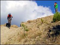
Single Track
Trails - Dry, rolling, open single track. Something for everyone.
Fun Factor - This place is awesome. So many areas to explore and so many options. Just go and have fun. Watch for cattle grazing!
Inks Lake is off the Coquihalla Highway approximately 13 kilometres before Kamloops. Follow the Inks Lake U-Turn Route Exit. Follow the road under the large culvert and you'll see a large salt/sand shed. Park at the shed and the trails will begin just across the cattleguard. You can also drive across the cattleguard and camp in this area. There are literally hundreds of kilometres of trails in this area, everything from singletrack to 4x4 roads to loose slippery hillclimbs. Its easy to get lost in there, since there are so many trails that criss-cross each other. A GPS can be very handy.