AdventureCatalogue.com is your online portal for finding the best adventure gear and outdoor mechandise in British Columbia and Alberta. We connect you with the outdoor professionals who sell the best gear!
AdventureCatalogue.com works with Bearfoot Canada to promote responsible travel in Canada's backcountry. Bearfoot Canada helps visitors explore great travel routes that combine nature, culture and adventure.
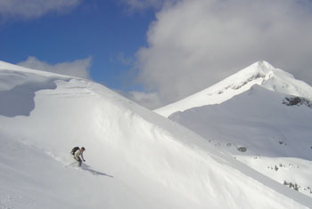
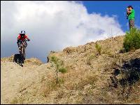
The Monashee Mountains boasts some of the most spectacular hiking areas in all of British Columbia. Walk through the Interior Rain Forests where the Cedar trees have stood for hundreds of years and the moss covers the forest floor. Follow the trails up to the Alpine meadows, jagged peaks and stunning white glaciers. If it's fishing you love, the Monashee Mountain Range has numerous pristine lakes that are full of healthy trout.
All hikers are encouraged to use extra caution when on the trails, due to frequent sightings of grizzlies and Black bears. The mountains are also home to Goats, Wolverines, Moose, Cariboo, Cougars and you never know if your lucky enough to catch a glimpse of the ever so elusive Sasquatch.
Monashee Provincial Park
From Lumby, drive 20km east on highway 6 to Cherryville. Turn Left onto Sugar Lake Road, and drive another 48km to the Monashee Provincial Park turn-off. Another 11km will bring you to the parking lot. This 7,513-hectare park incorporates over 30km of maintained trails with some of the areas most spectacular mountain vistas.
Mount Fosthall, the park's highest peak, reaches 2679 meters. This area is mainly suited for the more experienced hikers, although there are trails suited to the willing beginner. Spectrum Lake is an easy one-hour hike from the parking lot, and Little Peters Lake is a difficult three and a half hour hike. Peters Lake makes a good base-camp for many other day hikes. Please remember that there are no dogs allowed in the Monashee Provincial Park.
Guides are available equipped with Satellite imagery of the area, Global positioning units, Emergency communication devices, first aid training and a vast knowledge of the areas trails and attractions. So come and visit the Monashee Mountains and treat yourself to a truly unique wilderness experience. Use caution, this is Grizzly country.
Kate Lake, Sitkum Lake, Sugar Mountain & Goat Mountain
On your way to Monashee Provincial Park, you may want to stop and hike into Kate Lake. This Pristine Lake is set in a mountain bowl, surrounded by forested hills. To get there, drive east from Lumby about 20km and turn left onto Sugar lake Road. Follow Sugar Lake road for about 15km until you reach Kate Lake forest service road on your right. If you come to a bridge that crosses the outlet of Sugar Lake you have driven about a quarter kilometer to far. Follow Kate Lake Forest service road for approximately 2km where you will come to a fork in the road. Stay to the right here. At 2.5km, 3.5km, and 8.2km keep left. At 11.2km you will drive past the road to Sitkum Lake. Stay right at the following junction, and then keep left for the next three junctions. Now you will cross Sugar Creek, and about 100 meters past the bridge you will turn right. This road is only suitable for a well-equipped four-wheel drive. You may have to walk the 5.5km to the trailhead, as this road is very rough. The trailhead is clearly marked, on the left-hand side. From here it is a short 2.5km hike to the lake. Altogether, this is an 8km hike (depending on how far you can drive in), which takes about 2 hours. Your final altitude will be 1500 meters, with a gain of 600 meters. If you continue past the Kate lake trailhead and follow the road, you will reach the summit of Sugar Mountain where you will find an old forestry lookout that provides you with awesome views of the valleys below.
If you want to hike into Sitkum Lake or Goat Mountain, the Sitkum Lake turn off is at 11.2km on the Kate Lake forest service road. Turn right and travel on the Sitkum Lake forest service road for 12km until you reach the trailhead. This 8km sub-alpine trail has some steep, rocky areas, and is therefore recommended for experienced hikers only. Use caution, this is Grizzly country.
Tsuius Mountain Trails
Follow Sugar Lake Road for approximately 49km from highway 6. Turn left just past the turn off for Monashee Provincial Park, and follow the signs to the trailhead. This sub-alpine hiking area is difficult and is recommended for experienced hikers only. There are trailheads at Tsuius Creek, Tourmaline Creek, and just east of Mirror Lake. This is approximately a 6-hour hike, but longer ones may be arranged. Use caution, this is Grizzly country.
The Pinnacles & Monashee Lake
The Pinnacle Mountains are located just south of the Monashee Mountains and contain well marked trails to sparkling lakes and vantage points that enable you to see for hundreds of miles. Wild flowers blanket the Alpine meadows creating a mosaic of pastel colors and fresh mountain air. On a clear night the view of the stars is beyond belief. Its astonishing to see what's happening in our night skies with the total absence of artificial light.
The Pinnacles are accessed off South Fork Road, which is 26.5 kilometers east of Lumby on Highway 6. Turn left onto South Fork Road. At 2.3Km and 6.2Km keep right. At 12.5Km and 15.3Km keep left--Make sure you do not cross Monashee creek. At 18Km keep right for the Pinnacles, or left to reach the Monashee Lake trailhead. At approximately 23Km (Pinnacles), and 24Km (Monashee), you will park at a landing and find the trailhead sign. Follow the Cow trails into the woods, and watch for the red ribbons marking the trails. After reaching the Monashee Lake or Pinnacle Lake you will find that there are many day hikes available to the more experienced hiker. The altitude is approximately 1900 meters, with a gain of about 700 meters. These easy hikes cover a distance of 4.5km, with a hiking time of about 2 hours. Use caution, this is Grizzly country.
Beaven Mountain Trail
This 7km trail is located on South Fork Road, on your way to the Monashee Lake trailhead. 18km up south Fork Road, turn left, as though going to Monashee Lake. A few Kilometers from this turn-off, turn left again and drive to logged area, where you may park. From here you can see the trailhead to Beaven Mountain. Use caution, this is Grizzly country.
Vista Pass & Barnes Creek Trail
This is a 6km-hiking trail to the South Pinnacle Ridge. Turn Left onto South Fork Road off of highway 6, 26.5km east of Lumby. Follow the directions to the Pinnacles, but at 23km don't stop. Just a couple of Kilometers further will bring you to the trailhead. The trail is found on the North side of the creek. This trail meets up with the Barnes Creek Trail, which is an 8km Horseback riding/Hiking Trail. The Barnes creek Trailhead can be reached by turning left on to the gravel road to Keefer Lake, 60km east of Lumby on highway 6. Continue past Keefer and Holmes Lake to a four-wheel drive road. This is a scenic trail with a great view of the Pinnacles. Use caution, this is Grizzly country.
Twin Lakes
Drive 22km east from Lumby on Highway 6 and turn left onto the North Fork Road turnoff. Drive to the end of North Fork Road and turn onto Severide Creek Road. Continue down this road until you come to the parking lot, which also has an outhouse and the Twin Lakes hiking trail sign. This is a 6km hike, which takes approximately one and a half hours. Use caution, this is Grizzly country.
Mark Berger Traverse
The Traverse is near Cherryville. The trail is a difficult one, and takes about 3 days and a half days to complete this 27 km ridge walk. The trail direction is north to south and follows a ridge that connects 6-7 peaks. You can start at either end. The Twin Lakes end is less strenuous. The elevation is around 8000 feet. It starts at Twin Lakes where you summit Boulder Peak, and then continue south over Neopolitan Knob, Wimpy Peak, Bees Hive, towards Mt. Severide. As you round Mt Severide on the east side you will look down on Monashee Lake and across at the Pinnacles. From Monashee Lake you descend west down the valley to the parking lot.
Directions:
Drive to Vernon and take Highway 6 east to Cherryville. Follow on the North Fork Road past the Shell gas station. Once you reach the dirt road, drive 15 km and take a left. You will start to see Twin Lakes signs. Follow the signs up 27 km and that should get you to the trailhead. The trail is well marked up to Twin Lakes and down from Monashee Lake.
From the parking lot at lat 50 13.069 x long 118 17.930 head east along the trail along the north side of Monashee Creek through a lightly forested meadow to some timber and continue east till you come to a long slide section full of alder and lush forbs and herbs.
You will cross the creek bed which in spring is full of water, to the south side and then back again near the waterfall at the east end of the valley. At this point you head northeasterly along the east side of a steep gully and then across a large flat slab, and on steeply upwards under a massive cliff angling across the headwall slopes. It brings you to sub alpine meadows and the camping area.
The first great camping area which is located at 50 12.573 x 118 14.887 is a ground squirrel grizzly hunting area located by Monashee Lake, a small circular crystal clear glacial affair. Yes this is grizzly country.
BEFORE YOU GO
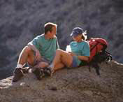
If an outing into the great Okanagan wilderness is on the agenda for your next vacation, a little advance planning is in order to ensure you enjoy a safe, worry-free and fun time.
Never venture out without first making sure you possess the right gear. Number one on your list should be a good topographical map of the area you're planning to explore. Although many of the trails are marked, it's easy to get lost or venture into uncharted terrain.
Next you want to have the appropriate clothing and footwear so you're comfortable during your outing.
Last but certainly not least please observe some rules and common courtesies for your own safety and to keep British Columbia beautiful. Exercise extreme caution at all times, and remember that the higher up you go, the thicker the vegetation, which makes the terrain much more rugged. And the weather can often be very different in higher elevations so be prepared if you dare to venture in those parts.
Remain on well marked trails so you don't get lost or destroy untouched terrain and always give logging trucks the right of way. Bring food, water and emergency supplies, but remember to take everything with you when you leave.
http://www.vtours.com/kelowna/hiking.htm
Outdoor Travel Tips
Be prepared for your chosen recreation - Stick to your turnaround time, take the proper equipment, have a trip plan, and use reference and guide books.
Always carry the essentials - Always be ready to stay out over night.
Never hike alone - Hike with a group and keep together. Travel at the speed of the slowest person. If a person becomes separated by going ahead or falling behind, they are more likely to become lost.
Do not Panic - Maintain a positive attitude if you become lost. Being lost is not dangerous if you are prepared.
Stay where you are - People who carry on after they become lost usually get further from the trail and from those who are looking for them.
Use signaling devices - Blowing a whistle, lighting a fire, and staying visible will help searchers find you. Remember that animals will not be attracted to your signals.
Build or seek shelter - Protect yourself from rain, wind and excessive sun. Be as comfortable as possible, but during daylight hours make sure you are visible to searchers in helicopters or planes.
Alpine Club of Canada
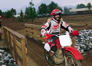
The Okanagan Section was created in 1996 to provide a meeting ground for Okanagan residents interested in outdoor recreation in a mountain setting. With access to the Skaha Bluffs and the Cascade, Coast, Cariboo, Monashee, Valhalla and Selkirk Ranges, the Okanagan Section provides opportunities for a wide variety of activities, including rock climbing, ice and alpine climbing, hiking, mountain biking, nordic and telemark skiing, ski mountaineering and snowshoeing.
Anyone seeking an encounter with nature, challenge, friendship, learning, and fun through such activities is invited to join us for our meetings, social events, courses, and section trips.
http://members.shaw.ca/accokanagan/ACCOK.html
The Vernon Outdoors Club
The Vernon Outdoors Club got its start in 1976 when Chrissie Stump and a few other kindred spirits got together and organized hikes around the Vernon area. From this modest beginning, it has developed into a strong, active organization with a membership close to two hundred wilderness-loving persons. The Club primarily schedules hiking and bicycling outings however many members enjoy a wide range of outdoor activities and are encouraged to share their interests with others.
http://www.vernonoutdoorsclub.org/
Okanagan Shuswap
Forest District
Located in the southern interior of British Columbia, the Okanagan Shuswap Forest District is one of 29 Districts in the Province. 57 Ministry of Forests staff located in Vernon, Penticton and Salmon Arm provide stewardship over diverse forest and range ecosystems in the Okanagan, Lower Similkameen and Shuswap drainages.
Please enter your comments in the Guestbook below.
Feel free to update our readers on your experiences.
Please correct our information or add further information about the trails and water routes on this page, or just say hello!
This page was last updated on: January 1, 2014
The Monster Guide
An information portal which describes travel risks and provides education so that visitors and the travel industry can better deal with crises, risk and fear management issues.
Nestled amongst valleys and rich farmland is the quaint and friendly little town of Lumby, known as the Gateway to the Monashee, the Mountains of Peace. Lumby is located on Highway 6, 22 miles (35 km) east of Vernon and 23 miles (36 km) west of Cherryville.
The view from Lumby is wonderful, as the picturesque Coldstream, Trinity and Creighton valleys all converge here. The awe-inspiring Monashee Mountain range and the varied landscape of streams and lakes beckons the avid outdoors enthusiast to go hiking, canoeing and fishing.